Geology and more
  • Αρχική
  • Μαθήματα
    • Νεοτεκτονική
    • Διδακτική της Γεωλογίας
    • Εισαγωγή στη Γεωλογία
    • Γεωλογία Φυσικού
    • Γεωλογία Χημικού
    • Μορφοτεκτονική (Μ.Π.Σ.)
    • Γεωλογία Ελλάδας - Εργαστήριο
    • Γεωτεκτονική Εξέλιξη - Εργαστήριο
    • Χαρτογραφήσεις Υπαίθρου
    • Τεκτονική Γεωλογία - Εργαστήρια
    • Γεωλογικές Χαρτογραφήσεις - Εργαστήρια
  • Blog
  • Επικαιρότητα
    • Elsevier: Earth and Planetary Science News
    • Science Daily: Earth Science News
    • GSA: Speaking of Geosciences
    • Nature Geoscience: current issue
    • Science: current issue
  • Εργασία/Jobs
  • Spectacular geology!
  • Βιογραφικό/CV
    • Publications >
      • Papers
      • Conference Proceedings
      • Editor
      • Abstracts
  • Επικοινωνία

New paper: Fault modelling, seismic sequence evolution and stress transferscenarios for the July 20, 2017 (MW 6.6) Kos–Gökova Gulf earthquake,SE Aegean

2/9/2020

Comments

 
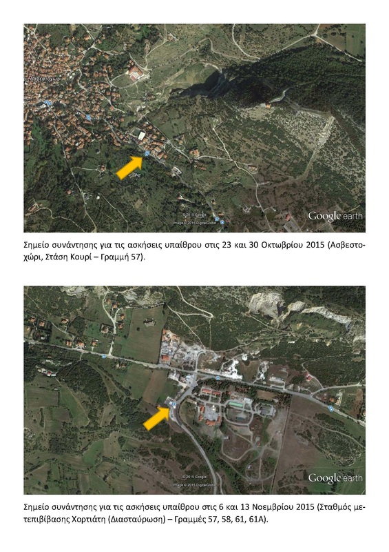
A new paper has just been published in Acta Geophysica by Sboras et al., on the 2017 Kos earthquake. The article may be accessed through this link.

Abstract
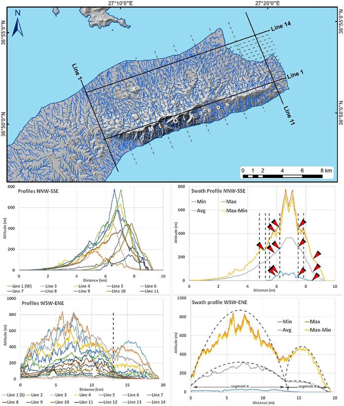
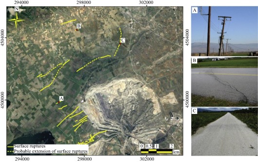
The July 20, 2017, MW 6.6 Kos–Gökova Gulf earthquake occurred offshore, near Bodrum of Turkey and Kos of Greece. It was one of the strongest in the broader area during the last many decades causing two deaths, many injuries and extensive damages. We investigated the evolution of the seismic sequence using seismological and geological tools. The aftershock sequence was relocated mainly in order to define the geometry of the main seismic source, depicting a NNW-dipping fault plane. It also revealed significant clustering, associated with other nearby faults, and asymmetric spatio-temporal evolution. Along with morphotectonic analysis on Kos Island, and other published seismological information (e.g. focal mechanisms), we modelled the seismic source of the mainshock, as well as the one of the strongest aftershocks (August 8, MW 5.3). We applied the Coulomb failure criterion in order to investigate the effect of the mainshock on the strongest aftershock, and the rest of the sequence as well. Using the same method, we also investigated the stress changes of both strongest shocks for the prevailing E–W-trending normal faults in this area. Among other conclusions and implications, we deduce that the prevailing tectonic setting of the Gökova Gulf consists of roughly E–W-striking normal faults forming inner horsts and grabens.
Picture
Comments

Σειρά διαλέξεων DeTect: The Deformation & Tectonics Talk Series

25/4/2020

Comments

 
Μία πολύ ενδιαφέρουσα σειρά ομιλιών σε τρέχοντα θέματα Τεκτονικής Γεωλογίας, διοργανώνεται από τον Yann Klinger του Institut de Physique du Globe de Paris. Οι ομιλίες γίνονται κάθε Παρασκευή στις 6 μ.μ. ώρα Ελλάδας (3pm GMT/UTC) με τη χρήση του λογισμικού τηλεδιασκέψεων Zoom. Η παρακολούθηση είναι δωρεάν για όλους.
Το τρέχον πρόγραμμα των ομιλιών, καθώς και οι σύνδεσμοι για τις ομιλίες του προηγουμένου κύκλου, είναι διαθέσιμα εδώ. 
Picture
Comments

New paper: Determination of local active tectonics regime in central and northern Greece, using primary geodetic data

20/4/2020

Comments

 
A new paper has just been published in Applied Geomatics by Lazos et al., dealing with the use of primary geodetic data in order to assess active tectonic deformation in central and northern Greece. The article may be accessed through this link.

Abstract
​Numerous active fault zones are detected into the central and northern part of Greece, while some of them are associated with destructive seismic events. Geometrically, the fault zone characteristics differentiate, showing both extensional and compressional tectonic features. The geodetic data used, recorded by permanent GPS/GNSS stations, provides a precise analysis the tectonic setting. In particular, 58 permanently installed GPS/GNSS stations are located into the study area, having collected primary data for 7 consecutive year time-period. The calculation of the East and North velocity components and their errors, respectively, derived from each GPS/GNSS station, was carried out implementing the triangulation methodology, based on the combination of three different GPS/GNSS stations each time. The dense GPS/GNSS stations network led to the construction of 1092 different triangles, while the centroid of each triangle was extracted. For each centroid, the following parameters were determined: (1) maximum horizontal extension, (2) minimum horizontal extension, (3) total velocity, (4) maximum shear strain, (5) area strain and (6) rotation. The extracted values were geostatistically processed (interpolation—grid pattern), showing low to medium values, especially north of the extension of the North Aegean Fault System, while the same parameters are high at the southern part of Greece. Therefore, the geological and seismological data are confirmed showing that Central–Northern Greece is tectonically less active than Southern Greece. However, it is mentioned that the neotectonic fault length can be related to the production of significant earthquakes, albeit in longer recurrence intervals.

Picture
Comments

New paper: Non-planarity, scale-dependent roughness and kinematic properties of the Pidima active normal fault scarp (Messinia, Greece) using high-resolution terrestrial LiDAR data

17/4/2020

Comments

 
A new paper has just been published in Jourνal of Structural Geology. It deals with numerical analysis of an exceptional outcrop of a normal fault scarp in SW Greece and the information that can by mined through this process. Work was based on the MSc Thesis of Giannis Karamitros.
You may download the paper free of charge before June 5, 2020, by following this link.

Abstract

Terrestrial LiDAR (TLS), photogrammetric and field data were collected during the years 2014, 2015 and 2017, at a 20-m long limestone scarp locality along the N–S striking, 70° west-dipping, active Pidima fault (Messinia, SW Peloponnese, Greece). This locality presents an artificially exhumed portion of an active fault plane, thus providing a unique opportunity to study kinematics and limestone scarp morphology (including its curvature and roughness). The survey of 2015 offered a high-density point cloud of the fault scarp with 6-mm working resolution, creating a very close to real life representation 3D model. We found that scarp geometry is non-planar with increasing convexity up-dip and increasing northwesterly dip-directions from north towards south, along strike. Non-planarity is also recorded from the morphological data along strike with the appearance of several, slip-parallel troughs and ridges with a mean distance (half-wavelength) of 0.75 m. The fault-plane roughness (absolute values) is scale dependent. The roughness configuration attains a slip-parallel pattern for observation scales above 1-cm. At observations scales less than 1-cm a slip-normal pattern is weakly visible. The obtained TLS results agree with field data (manual compass measurements) and macroscopic observations. We infer an earthquake magnitude of 6.2 ± 0.2 for the last event along the Pidima fault based on the measured thickness of the smooth stripe that was imaged by t-LiDAR along the non-exhumed surface of the scarp.

Picture
Comments

Δωρεάν παρακολούθηση του EGU 2020: Sharing Geoscience Online

14/4/2020

Comments

 
Η σειρά των ετήσιων συνεδρίων της EGU (European Geosciences Union) είναι το μεγαλύτερο γεγονός στο χώρο των γεωεπιστημών στην Ευρώπη, και δεύτερο μεγαλύτερο στον κόσμο μετά από αυτό της AGU. Το φετινό συνέδριο αναβλήθηκε λόγω της πανδημίας COVID-19, ωστόσο από τις 4 έως τις 8 Μαΐου 2020 μέρος του θα διεξαχθεί ψηφιακά, με την συμμετοχή και παρακολούθηση να είναι δωρεάν για όλους. 
Πρόκειται για μία μοναδική ευκαιρία για να παρακολουθήσει κανείς ένα από τα μεγαλύτερα συνέδρια παγκοσμίως, το οποίο καλύπτει όλο το φάσμα των γεωεπιστημών, και στο οποίο συγκεντρώνονται κάθε χρόνο δεκάδες χιλιάδες επιστήμονες από όλο τον κόσμο.
Πληροφορίες για τον τρόπο παρακολούθησης, το πρόγραμμα των παρουσιάσεων κλπ βρίσκονται εδώ: https://egu2020.eu/sharing_geoscience_online/
Οδηγίες βήμα-βήμα για το πώς μπορείτε να βρείτε το περιεχόμενο που σας ενδιαφέρει και πώς μπορείτε να καταρτίσετε το προσωπικό σας πρόγραμμα μπορείτε να δείτε σε αυτό το αρχείο.
Picture
Comments

What a River Can Tell Us About Earthquakes

14/4/2020

Comments

 
By @DeeNinis (Twitter)
Want to know more about ground-rupturing #earthquakes on New Zealand’s Wellington Fault? Join me on a virtual field trip in Going Places Episode 8 to see impressive fault-offset features and hear why we think activity on this fault has varied through time.
Comments

Εικονική άσκηση υπαίθρου από το Τμήμα Γεωλογίας του University of Otago (Νέα Ζηλανδία)

12/4/2020

Comments

 
Λόγω της ασθένειας COVID-19 και των περιοριστικών μέτρων σε όλο τον κόσμο, μία παράπλευρη απώλεια ήταν η ματαίωση πολλών εκπαιδευτικών ασκήσεων υπαίθρου για τους φοιτητές της Γεωλογίας. Το Πανεπιστήμιο του Otago στη Νέα Ζηλανδία, οργάνωσε μία εικονική άσκηση υπαίθρου χρησιμοποιώντας γεωγραφικά συστήματα πληροφοριών και πολυμεσικό υλικό. Μπορείτε να την ακολουθήσετε κι εσείς εδώ: https://arcg.is/0vTCPa (​@jamesscottgeol στο Twitter).
Picture
Comments

Δωρεάν webinar: Mapping Displacement and Subsidence with Time-series Radar (15 Απριλίου 2020)

12/4/2020

Comments

 
Ένα ενδιαφέρον δωρεάν webinar από το Αμερικανικό Ινστιτούτο Γεωεπιστημών σχετικά με τη χρήση εικόνων radar για την  χαρτογράφηση επιφανειακών παραμορφώσεων λόγω υπεράντλησης (15/04/2020, 8 μ.μ. ώρα Ελλάδας).
Πληροφορίες και εγγραφή: https://www.americangeosciences.org/webinars/mapping-displacement-and-subsidence-time-series-radar
Picture
Comments

The Archaeology of Europe’s Drowned Landscapes - Open Access Book

12/4/2020

Comments

 
Εκδόθηκε ο τόμος με τίτλο The Archaeology of Europe’s Drowned Landscapes, μία συλλογή εργασιών με αντικείμενο τα βυθισμένα αρχαιολογικά ευρήματα της Ευρώπης. Εκτός από αρχαιολογικό, ο τόμος έχει και μεγάλο γεωλογικό ενδιαφέρον, καθώς για τη βύθιση των αρχαιοτήτων έχουν δράσει γεωλογικές διαδικασίες του Ύστερου Ολοκαίνου.
Ο τόμος είναι open access, δηλαδή δωρεάν διαθέσιμος για όλους και διατίθεται εδώ: https://www.springer.com/gp/book/9783030373665
Picture
Comments

ΧΑΡΤΟΓΡΑΦΗΣΕΙΣ ΥΠΑΙΘΡΟΥ - Αποτελέσματα Ιουνίου 2019

2/7/2019

Comments

 
Ανακοινώνεται η βαθμολογία του μαθήματος Χαρτογραφήσεις υπαίθρου για την εξεταστική περίοδο Ιουνίου 2019. Η βαθμολογία θα κατατεθεί στη Γραμματεία την Παρασκευή, 5/7/2019.

​Οι διδάσκοντες
Χαρτογραφήσεις_Υπαίθρου_-_Βαθμολογία_Ιουνίου_2019.pdf
File Size: 79 kb
File Type: pdf
Download File

Comments

ΕΙΣΑΓΩΓΗ ΣΤΗ ΓΕΩΛΟΓΙΑ - Αποτελέσματα εξετάσεων Ιανουαρίου 2018

21/2/2018

Comments

 
ΕΙΣ033_-_Αποτελέσματα_Ιανουαρίου_2018.pdf
File Size: 89 kb
File Type: pdf
Download File

Comments

ΧΑΡΤΟΓΡΑΦΗΣΕΙΣ ΥΠΑΙΘΡΟΥ - Βαθμολογία Ιουνίου 2017

6/7/2017

Comments


ΧΑΡΤΟΓΡΑΦΗΣΕΙΣ ΥΠΑΙΘΡΟΥ - Βαθμολογία Ιουνίου 2017 by Alex Chatzipetros on Scribd

Comments

ΝΕΟΤΕΚΤΟΝΙΚΗ - Βαθμολογία Ιουνίου 2017

6/7/2017

Comments


ΝΕΟ26 - Βαθμολογία Ιουνίου 2017 by Alex Chatzipetros on Scribd

Comments

Με ένα σφυρί και μία λούπα, το ντοκιμαντέρ της Ιωάννας Παρλάντζα

19/2/2017

Comments

 
Comments

Ρεπορτάζ της ΕΡΤ 3 για τα drones στη Γεωλογία

19/2/2017

Comments

 
Ρεπορτάζ της ΕΤ3.
Comments

ΕΙΣΑΓΩΓΗ ΣΤΗ ΓΕΩΛΟΓΙΑ - Αποτελέσματα εξετάσεων Σεπτεμβρίου 2016

27/9/2016

Comments


ΕΙΣΑΓΩΓΗ ΣΤΗ ΓΕΩΛΟΓΙΑ - Βαθμολογία Σεπτεμβρίου 2016 by Alex Chatzipetros on Scribd

Comments

Γεωπάρκο Γρεβενών - Γενέτειρα της Τηθύος: ημέρα γνωριμίας

22/10/2015

Comments

 
Picture
Comments

ΝΕΟΤΕΚΤΟΝΙΚΗ - Θέματα παρουσιάσεων

20/10/2015

Comments

 
Picture
Όσοι φοιτητές επιθυμούν, μπορούν να ετοιμάσουν και να παρουσιάσουν σύντομα ένα θέμα από τα προτεινόμενα. Οι παρουσιάσεις θα γίνονται στην αρχή των παραδόσεων, έτσι ώστε να ακολουθεί συζήτηση. Οι παρουσιάσεις θα πρέπει να είναι σε PowerPoint και περιληπτικές (όχι πάνω από 4-5 διαφάνειες), καθώς ο χρόνος θα είναι περιορισμένος (3-4 λεπτά). 
Όσοι το επιθυμούν μπορούν να δηλώσουν το όνομά τους δίπλα από το θέμα που τους ενδιαφέρει στο αρχείο που βρίσκεται διαθέσιμο στην ενότητα "Ανακοινώσεις" του ηλεκτρονικού μαθήματος στη διεύθυνση elearning.auth.gr. Η ημερομηνία παρουσίασης καθορίζεται σε συνεννόηση με τους διδάσκοντες.

Comments

ΕΙΣΑΓΩΓΗ ΣΤΗ ΓΕΩΛΟΓΙΑ - Ανακοίνωση για τις ασκήσεις υπαίθρου 2015

13/10/2015

Comments

 
Picture
Picture
Comments

ΕΙΣΑΓΩΓΗ ΣΤΗ ΓΕΩΛΟΓΙΑ - Αποτελέσματα Εξετάσεων Σεπτεμβρίου 2015

25/9/2015

Comments

 
Ανακοινώνονται τα αποτελέσματα των εξετάσεων του μαθήματος "Εισαγωγή στη Γεωλογία" για την εξεταστική περίοδο Σεπτεμβρίου 2015.
Picture
Picture
Comments
<<Previous


    Archives

    September 2020
    April 2020
    July 2019
    February 2018
    July 2017
    February 2017
    September 2016
    October 2015
    September 2015
    August 2015
    July 2015
    June 2015
    February 2015
    January 2015
    December 2014
    November 2014
    October 2014
    September 2014
    July 2014
    May 2014
    March 2014
    February 2014
    January 2014
    December 2013
    November 2013
    October 2013
    September 2013
    June 2013
    May 2013
    April 2013
    March 2013
    February 2013
    January 2013
    December 2012
    November 2012
    October 2012
    September 2012
    August 2012
    July 2012
    June 2012
    May 2012
    April 2012
    March 2012
    February 2012
    January 2012
    December 2011
    November 2011
    October 2011
    September 2011
    July 2011
    June 2011
    May 2011
    April 2011
    March 2011

    RSS Feed

Powered by Create your own unique website with customizable templates.
Photos used under Creative Commons from stroud4341, Official U.S. Navy Imagery, dsearls, wallygrom (very busy at work), James St. John, joiseyshowaa