A new paper has just been published in Jourνal of Structural Geology. It deals with numerical analysis of an exceptional outcrop of a normal fault scarp in SW Greece and the information that can by mined through this process. Work was based on the MSc Thesis of Giannis Karamitros.
You may download the paper free of charge before June 5, 2020, by following this link.
Abstract
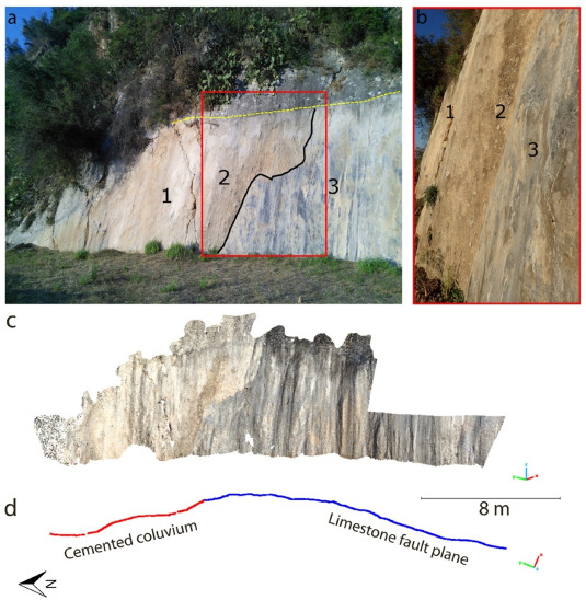
Terrestrial LiDAR (TLS), photogrammetric and field data were collected during the years 2014, 2015 and 2017, at a 20-m long limestone scarp locality along the N–S striking, 70° west-dipping, active Pidima fault (Messinia, SW Peloponnese, Greece). This locality presents an artificially exhumed portion of an active fault plane, thus providing a unique opportunity to study kinematics and limestone scarp morphology (including its curvature and roughness). The survey of 2015 offered a high-density point cloud of the fault scarp with 6-mm working resolution, creating a very close to real life representation 3D model. We found that scarp geometry is non-planar with increasing convexity up-dip and increasing northwesterly dip-directions from north towards south, along strike. Non-planarity is also recorded from the morphological data along strike with the appearance of several, slip-parallel troughs and ridges with a mean distance (half-wavelength) of 0.75 m. The fault-plane roughness (absolute values) is scale dependent. The roughness configuration attains a slip-parallel pattern for observation scales above 1-cm. At observations scales less than 1-cm a slip-normal pattern is weakly visible. The obtained TLS results agree with field data (manual compass measurements) and macroscopic observations. We infer an earthquake magnitude of 6.2 ± 0.2 for the last event along the Pidima fault based on the measured thickness of the smooth stripe that was imaged by t-LiDAR along the non-exhumed surface of the scarp.
You may download the paper free of charge before June 5, 2020, by following this link.
Abstract
Terrestrial LiDAR (TLS), photogrammetric and field data were collected during the years 2014, 2015 and 2017, at a 20-m long limestone scarp locality along the N–S striking, 70° west-dipping, active Pidima fault (Messinia, SW Peloponnese, Greece). This locality presents an artificially exhumed portion of an active fault plane, thus providing a unique opportunity to study kinematics and limestone scarp morphology (including its curvature and roughness). The survey of 2015 offered a high-density point cloud of the fault scarp with 6-mm working resolution, creating a very close to real life representation 3D model. We found that scarp geometry is non-planar with increasing convexity up-dip and increasing northwesterly dip-directions from north towards south, along strike. Non-planarity is also recorded from the morphological data along strike with the appearance of several, slip-parallel troughs and ridges with a mean distance (half-wavelength) of 0.75 m. The fault-plane roughness (absolute values) is scale dependent. The roughness configuration attains a slip-parallel pattern for observation scales above 1-cm. At observations scales less than 1-cm a slip-normal pattern is weakly visible. The obtained TLS results agree with field data (manual compass measurements) and macroscopic observations. We infer an earthquake magnitude of 6.2 ± 0.2 for the last event along the Pidima fault based on the measured thickness of the smooth stripe that was imaged by t-LiDAR along the non-exhumed surface of the scarp.
 RSS Feed
